
|
 |
Rule 105 Territory - Not to exceed 15 mph on entire trackage.
No trackage exists on this line between Fort Erie and Chippawa.

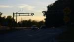
Mile 14.0 (Jct. with Montrose Subdivision) : McLeod Road, Niagara Falls : Mile 14.0 is located at mile 3 of the CP Montrose Subdivision. The switch to the CP Chippawa Industrial Spur is located in from of Mount Carmel.
Mile 13.8 : McLeod Road, Niagara Falls : McLeod Road has been blocked to through vehicle traffic for years. You can get a shot here from the east end of McLeod Road, off of River Road.
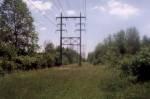
Mile 13.2 : Marineland Parkway : This is Marineland Parkway. It is a 4 lane road. You can get a few pictures here, but you can't stop on this road. You would have to park your car somewhere. Job 1 out of Welland Yard is the train that ventures down this line.
Mile 13.0 : Marineland Parking Lot : Not mentioned in the timetable, there is a parking lot beside the CP Chippawa Spur at mile 1.2 . You can park your car here and walk across the grass to get a few pictures of the train pulling up through the trees from the north. Job 1 services Sohio inside the grounds of Marineland. Sorry...you can't take any pictures, unless you pay!
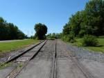
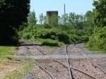
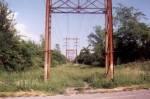
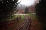
Mile 12.9 : Chippawa Pkwy : Saint Gobain is located at the end of the CP Chippawa Spur. You can get some good pictures here of both the train on the CP Chippawa Spur, and in Saint Gobain. The track is really pretty snaky just north of the switch to Saint Gobain.
Mile 12.85 : End Of Steel : The bumper is located at this location. Job 1 pulls up to the bumper when pulling out of Saint Gobain with cars. Try getting some pictures here!
The CP Chippawa Spur was once part of the Michigan Central, which ran between Niagara-On-the lake and Fort Erie.
The Chippawa Industrial Spur is a remnant segment of the old Michigan Central that ran between Fort Erie and Niagara-on-the lake.
I have yet to determine when the section between Niagara Falls and Niagara On-the-lake was abandoned, but I am guessing sometime in wither the 1950's or 1960's.
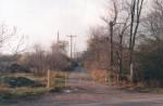
I have learned that the section from Fort Erie to the south of the Chippawa Creek bridge was abandoned in 1941.
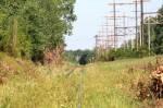
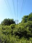
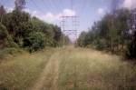
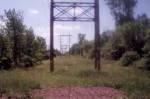
The photos showing the hydro towers only show the ROW that this rail line took, between Fort Erie and Chippawa. The rail line did not run along beside this electrical grid, as I have mention on this page in the past. I had always thought the rail line was omly removed since the 1970's, but I was incorrect.
These days the area of the present Chippawa Spur is only about one and a half miles in length. It runs off of the present CP Montrose Spur in Niagara Falls at mile 2.97. The CP Montrose Spur was once a Subdivision and was previous to that the old trackage of the CP Hamilton Subdivision and was built for Michigan Central, New York Central and Pen Central, through track inheritance.
This line services two industries. The first being Saint Gobain at the end of the line and Washington Mills (Sohio), located on the west side of Marineland. You cannot get to the switch at Sohio to railfan unless you pay the admission to Marineland as the switch is on Marineland property.
Saint Gobain and Washington Mills (Sohio) are serviced by CP Welland Yard's were once serviced by Job 1 during the week every day, when switching was required. These days new crews service the industries when required.
As the Michigan Central, New York Central, Penn Central and Conrail once operated this line, I don't have much knowledge of what trains traveled this line during the majority of the 1900's, until CP took over in the 1980's.
I was told that the line once used to see 100 cars a day. I'm not sure if it was between the 2 companies or just for Saint Gobain. Saint Gobain used to be called Norton.
Only one 4 axle locomotive and its' railcars are permitted to operate on this line as a built train. The train heads south from the Jct. switch at mile 2.97 of the CP Montrose Subdivision and to Saint Gobain with the locomotive on the south end of the movement. After servicing the line, the train will reverse north up the CP Chippawa Industrial Spur back to the CP Montrose Spur.
In regards to the former trackage south of Chippawa on this line used to be where the power lines travel these days. When it comes to the line operating up to Niagara-on-the Lake, that portion I never have checked out. I found out that it was too hard to follow because there aren't many traces of the line these days in the trees or landscape.
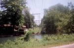
The reason the bridge across Chippawa Creek stayed in place for so long after 1941 and why it wasn't cut back in 1941 was that a business just on the south side of the bridge by the name of E. Weightman & Sons was receiving rail service. The rail line ran along Dock Street to the end of track.
If my memory is correct, the ROW of the CP Niagara Industrial Lead was part of this line at one time and it used to pass under the CN Grimsby Subdivision just west of Portage Road. The line was cut back in the last number of decades when it was just later made into the interchange track between CN during the Conrail and CP days. That tunnel underpass was later filled in back in probably the 1950's or 1960's, shortly after the line was abandoned west of Stanley Avenue in Niagara Falls.
I will say that this line to Niagara-on-th Lake is one rail line that I have not document past the west end of the CP Niagara Industrial Lead, in any way, though I haven't made any connection to that line being part of this line in my writings of history on it's own page on my site. The line going to Niagara-on-the Lake is to hard to follow these days.
These photos are of the Chippawa Industrial Spur.
42 photos in gallery
 Mile 12.85 Looking South (2010) |
 Mile 12.90 Looking North (1998) |
 Mile 12.90 Looking North (1998) |
 Mile 12.90 Looking North (2010) |
 Mile 12.90 Looking South (1998) |
 Mile 12.90 Looking South (2010) |
 Mile 12.95 Looking North (2010) |
 Mile 12.95 Looking South (2010) |
 Mile 13.00 Looking North (2010) |
 Mile 13.15 Looking North (1998) |
 Mile 13.15 Looking North (2010) |
 Mile 13.15 Looking South (1998) |
 Mile 13.30 Looking North (1999) |
 Mile 13.30 Looking South (1999) |
 Mile 13.40 Looking North (1999) |
 Mile 13.40 Looking South (1999) |
 Mile 13.51 Looking North (2014) |
 Mile 13.51 Looking South (2014) |
 Mile 13.51 Looking Southwest (2014) |
 Mile 13.55 Looking North (1998) |
 Mile 13.55 Looking East (2012) |
 Mile 13.55 Looking South (1998) |
 Mile 13.55 Looking South (1998) |
 Mile 13.55 Looking West (2004) |
 Mile 13.55 Looking West (2014) |
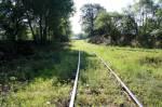
 Mile 13.75 Looking North (1997) |
 Mile 13.75 Looking South (1997) |
 Mile 13.85 Looking South (2011) |
 Mile 13.90 Looking South (2011) |
 Mile 13.99 Looking South (2014) |
 Mile 13.99 Looking South (2014) |
 Mile 13.99 Looking South (2014) |
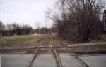
 Mile 14.00 Looking North (2001) |
 Mile 14.00 Looking North (2002) |
 Mile 14.00 Looking North (2011) |
 Mile 14.00 Looking North (2014) |
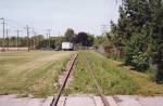
 Mile 14.00 Looking South (2002) |
 Mile 14.00 Looking South (2003) |
 Mile 14.00 Looking South (2011) |
 Mile 14.00 Looking South (2011) |
 Mile 14.00 Looking South (2014) |
 Mile 14.00 Looking South (2014) |
These photos are of the former PC trackage out of Fort Erie, north into Chippawa, along the Niagara River, connecting into what is presently mile 12.9.
27 photos in gallery
 Mile 0.50 Looking East (1999) |
 Mile 0.50 Looking West (1999) |
 Mile 0.70 Looking East (1999) |
 Mile 0.70 Looking West (1999) |
 Mile 1.50 Looking East (2001) |
 Mile 1.50 Looking West (2001) |
 Mile 2.00 Looking North (1999) |
 Mile 2.00 Looking South (1999) |
 Mile 2.10 Looking North (2013) |
 Mile 2.10 Looking North (2013) |
 Mile 2.10 Looking North (2018) |
 Mile 2.10 Looking South (2013) |
 Mile 2.10 Looking South (2013) |
 Mile 2.10 Looking South (2018) |
 Mile 4.40 Looking North (1999) |
 Mile 4.40 Looking South (1999) |
 Mile 6.70 Looking North (1999) |
 Mile 6.70 Looking South (1999) |
 Mile 7.00 Looking North (1999) |
 Mile 7.00 Looking South (1999) |
 Mile 10.23 Looking Northwest (1999) |
 Mile 10.23 Looking South (1999) |
 Mile 11.40 Looking North (1999) |
 Mile 11.40 Looking South (1999) |
 Mile 12.50 Looking North (1999) |
 Mile 12.50 Looking South (1999) |
 Mile 12.75 Looking East (1992) |
These photos are of the Sohio Lead off of the CP Chippawa Industrial Lead, within the Marineland property.
2 photos in gallery
 Looking Northwest (1999) |
 Looking East (1999) |
These photos are of the old Saint Gobain Lead off of the CP Chippawa Industrial Lead, just north of Chippawa Creek Road in Chippawa, which is part of Niagara Falls.
1 photos in gallery
 Looking Northwest (1998) |
